Fleet — drones with sensors (rgb/thermal/lidar), battery, and status (available/in_flight/maintenance/grounded).
← MCP server registry
Physical & geospatialPublic source
Drone Imagery MCP Server
An aerial inspection / drone imagery platform for ADK-Rust Enterprise energy & utility agents. 23 MCP tools covering a drone fleet, sites & inspection assets, flights/missions, geotagged imagery, detections with…
What it gives an agent
A purpose-built capability behind one MCP connection.
The server owns its domain logic and publishes a tool contract an MCP client can discover. ADK-Rust can load that contract into an agent, normalize each schema for the chosen model provider, and keep the connection lifecycle outside the agent’s business logic.
Sites & assets — inspection sites and assets (towers/poles/spans) with a required vegetation clearance (meters) and geolocation.
Flights — scheduled missions; flight status transitions reflect drone availability (a flying drone is in_flight; completion frees it).
Imagery — geotagged image records (URI references + sensor + lat/lon/altitude), optionally tied to an asset.
Detections — for vegetation detections with a measured clearance, severity and encroachment are auto-computed from the asset's required clearance (deficit ratio →…
Vegetation risk — vegetation_risk aggregates an asset's detections into a 0–100 score + level (worst deficit × confidence); risk_queue ranks the whole network.
Remediation — flag_for_remediation dispatches a crew with a priority derived from severity (P1–P4); status lifecycle to completion.
Architecture
How Drone Imagery MCP Server fits into an agent system.
The model never needs the implementation details or credentials of the system behind the server. It sees reviewed tool definitions. The MCP client handles discovery and calls, while the server keeps ownership of validation, policy, and communication with its domain system.
01
ADK-Rust agent
Chooses a capability from the reviewed tool catalog.
02
MCP client
Discovers schemas, sends calls, and receives typed content.
03
Drone Imagery MCP Server
Validates the request and owns 23 documented tool contracts.
04
Domain system
Keeps the API, data, credentials, and business rules behind the server.
From the project documentation
The server’s published architecture
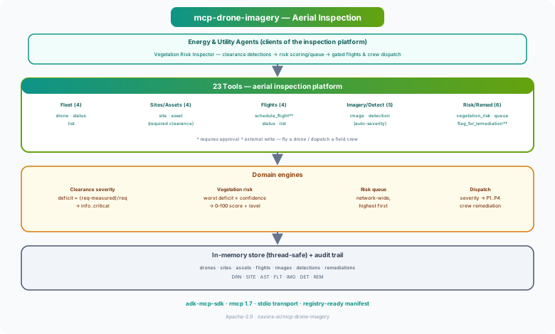
Tool catalog
What can an agent ask Drone Imagery MCP Server to do?
Each tool has a stable name, a human-readable purpose, and a JSON input contract discovered during MCP initialization. Risk classes come from the project’s registry manifest when one is available.
23 named tools
register_droneRegister a drone in the fleet
internal writeget_droneGet a drone by id
read onlylist_dronesList drones by status
read onlyset_drone_statusSet a drone's status
internal writecreate_siteCreate an inspection site
internal writelist_sitesList inspection sites
read onlycreate_assetCreate an inspection asset with required clearance
internal writelist_assetsList assets at a site
read onlyschedule_flightSchedule a drone flight (physical) — gated
external writeget_flightGet a flight by id
read onlylist_flightsList flights by site/status
read onlyset_flight_statusSet a flight's status (reflects drone availability)
internal writeGovernance
Understand the effect of every tool.
A server connection inherits the authority of its credentials and deployment environment. The declarations below come from this project’s README and MCP registry manifest; your application still decides which tools an agent receives and where approval is required.
13 read only8 internal write2 external write
- Two writes are physical actions and are gated (requires_approval, external_write): schedule_flight (commits a drone to fly — validates availability and ≥25% battery) and…
- Sensible guards — flights are refused for unavailable or low-battery drones; remediation priority follows detection severity. Everything is on the audit trail (audit_log).
- Reads are read_only. Imagery is referenced by URI/handle, never raw bytes. Sample data is fictitious.
MCP surface
What the current documentation declares.
MCP can carry tools, resources, prompts, structured results, progress, cancellation, and long-running work. This record highlights the modern protocol features explicitly mentioned by this repository.
Completion
ADK MCP SDKrmcpRegistry manifest
Install and connect
Follow the project’s documented starting point.
Install the server in the environment that owns its credentials and domain access. Add it to your MCP host, verify the discovered tools, and narrow the toolset before giving it to a production agent.
Install
cargo install mcp-drone-imageryADK-Rust connection shape
let toolset = McpToolset::from_stdio(
    "mcp-drone-imagery",
    ["mcp-drone-imagery"],
).await?;

let agent = LlmAgentBuilder::new("agent")
    .tools(toolset.tools().await?)
    .build()?;
Commands and configuration are extracted from the public README. Confirm prerequisites, environment variables, and release-specific options in the official documentation before deployment.
Official documentation
Continue with the project maintainers’ source of truth.
This page provides an approachable map of the server. The repository remains authoritative for exact schemas, prerequisites, configuration, examples, tests, releases, and security updates.
Keep exploring
More in physical & geospatial.
Environment / Runtime MCP ServerRuntime control plane for ADK-Rust Enterprise. Manages runtime environments, worker pools, deployment bundles, configuration sync, provider routing, validation gates, promotion, rollback, and configuration drift…10 toolsIoT MCP ServerIoT device management — telemetry, commands, alerts, digital twins, fleet management, OTA updates, geofencing22 toolsMaps & Geolocation MCP ServerGeolocation and routing for ADK-Rust Enterprise agents. Provides 7 MCP tools for geocoding, routing, elevation, POI search, and distance matrices — zero configuration, no API keys, powered by OpenStreetMap.7 tools
Source record
Release and repository metadata for this catalog entry.
- Version
- 1.0.0
- License
- Apache-2.0
- Tools
- 23
- Revision
- 55dd03778aeb
- Updated
- Jun 9, 2026
Transportsstdio